
Google Mapping – Byron Bay

Week 39 OF 52 ANCESTORS CHALLENGE
PROMPT: MAP IT OUT
Byron Bay is the touchstone of my paternal family; a place where generations lived, worked and played. It is also the centre of several family ‘myths’. This map, created using Google My Maps, is designed to plot the lives of the Harris, Woolley and Poolman families in the town during the first half of the twentieth century.
The Byron Bay that my paternal great grandfather Herbert John Harris moved to in 1915 to work on the ‘old’ town jetty is long gone, as has the jetty. The Byron Bay that Edwin Richard Woolley found when he moved there to work on the Byron Bay Shire is long gone as is the town that Harry Poolman moved to in 1912 to become Chief Engineer of NORCO.
All three families moved to Byron Bay well before electricity was connected to the town in 1926. When Herbert John Harris bought the Orient Coffee Palace in 1918 his telephone number was Byron Bay No 36.
These men and their families were part of a community, with its butter factory, meatworks, piggery and whaling station. That town is a far cry from the community described in an August 2019 Vanity Fair article as “The Coast of Utopia‘, home to millionaires, Hollywood movie stars and Instagram influencers.
Hopefully I have shown in this map just how enmeshed my family was in the growth of Byron Bay – in the changing nature of the town and in the sporting and social life in Byron Bay during the first half of the 20th century.
Why Google My Maps?
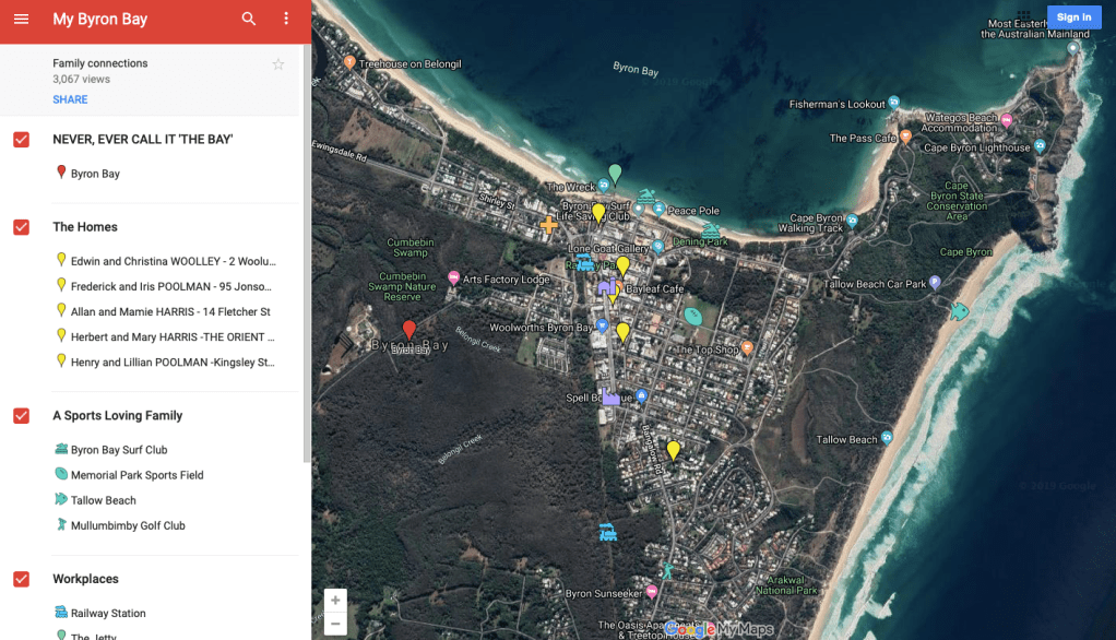
I chose My Maps because I wanted to use a current map of Byron Bay featuring well known attractions – restaurants, cafes, beaches and boutiques (some with international reputations) – and overlay this with locations, along with accompanying images and information, that were important to the Harris, Woolley and Poolman families .
I chose to use the satellite view because features such as the beaches that Byron Bay is famous for are instantly recognisable and attractive in this view.
The layers
Information about the Harris, Woolley and Poolman families was gathered from primary sources eg. documents, interviews, and from many secondary sources eg. family trees, ancestry.com. This needed to be organised in a coherent manner so that it was easily read and interpreted on the map.
To do this, information was sorted into locations, and each location was then put into a category, or layer.
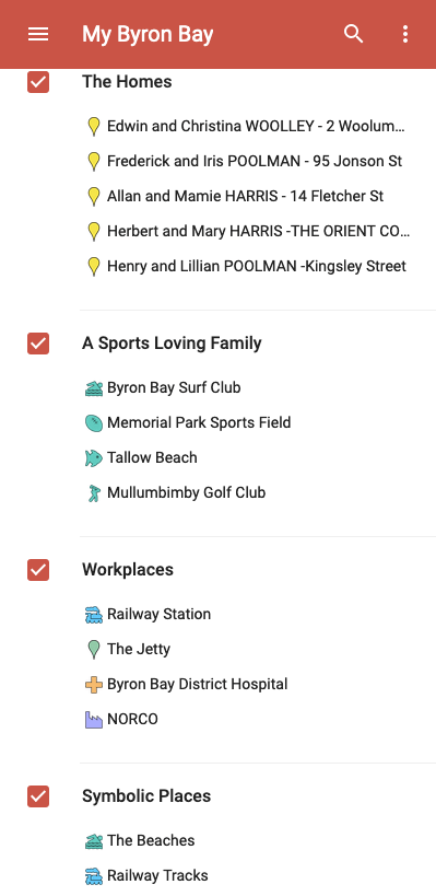
I chose to use four layers of information in my map. They were:
- The Homes
- A Sports Loving Family
- Workplaces
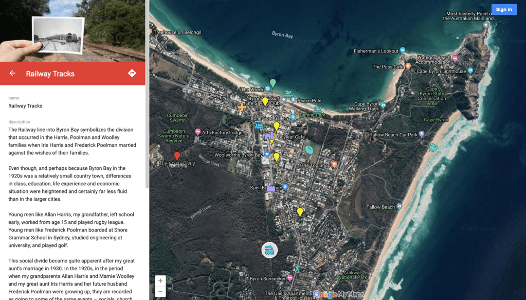
- Symbolic Places
Information panels
When I created location markers I chose to add both text and images to a corresponding panel that appears on the left hand side of the screen. This great feature of My Maps enabled me to really personalise my map of Byron Bay.

The homes
The first layer placed over the ‘current’ view of Byron Bay was the one designed to show where the families lived over time. By using census records to find correct addresses, I was able to plot accurate locations. These were pinned onto the map using a series of yellow location markers.
It was interesting to note that most homes were built close to the old railway line and/or main road into the town. They were all relatively close to the two jetties that were critical to Byron Bay’s infrastructure..

A sports loving family
The location markers for this layer feature appropriate icons.
A location that was important to my sports loving family was the Memorial Park Sports Field. It is marked on the satellite view by an icon featuring a football. The left hand panel features text supported by a photos of grandfather’s rugby league team as well as an article from Trove about a hockey match that reported that my grandmother, Mamie Woolley, ‘played well”.

Workplaces
Interestingly, of the four workplaces that were important to my extended family, only the Byron Bay Hospital still exists and it is now situated on the outskirts of the town. Each workplace has been identified by an appropriaie icon.

Symbolic places
The three families were from different social and economic backgrounds and they held quite different positions in Byron Bay. These places are where the lives of the members of the families intersected. The town’s beaches were great equalisers.
Conclusion
What I thought would be a simple task became increasingly complex but much more interesting as my family’s places, events, and relationships meshed and became a microcosm of life in Byron Bay. The development of the town’s infrastructure, industries, and its sporting and cultural life becme entwined in the map.
The mapping exercise was a powerful and highly visual way to capture a coherent yet personal history of a lost Byron Bay. It was easy to see that the My Maps program could be applied to any number of the facets of family history.

Amazing use of the technology. makes it all come to life
LikeLiked by 2 people
Well done Brian – inventive way to present the family history in Byron Bay. You have utilized modern technology to your own advantage which should make it of interest to other relatives this way
LikeLiked by 1 person
It’s very interesting, very well done, but I have no idea where Byron Bay is!!! The only clue I had was in the title of your Blog, in the bar on the left, at the top: From Prisons and Poorhouses, The journey from Britain to C21 Australia. So Byron Bay is in Australia. At any rate, as I said, very well, done, gave me a few ideas for my own family. Thank you for sharing.
LikeLike
Many thanks for your really valuable comment Paula. Byron Bay is iconic to Australians and many of us aspire to live the Byron lifestyle and it never occurred to me that there is a world of people out there who have never heard of the place – unless they read Vanity Fair etc. And given that the prompt was “Map it out”, it would have been a REALLY good idea to place Byron on a map of Australia in the post. PS If you ever visit Australia make sure to put Byron Bay on your itinerary. It’s stunning.
LikeLike
Fantastic use of My Maps. I have used it a little myself to help visualize the migration of my ancestors, but not like this, wow! I live in southwest Florida and have visited Australia twice, but have not heard of Byron Bay. (I thought perhaps it was in the San Francisco Bay area until I read further on your blog.) I have now looked at a larger map and will definitely include Byron Bay on my next trip “down under”.
LikeLike